 |
| www.gorp.com |
In addition to our planned main destination
Noel Kempff National Park there’s four other national parks in the Santa Cruz
department, as well as seven other nationally and 18 municipally protected
areas, all part of SNAP (Sistema
Nacional de Áreas Protegidas, National System of Protected Areas). All national
parks are governed by SERNAP (Servicio Nacional de Áreas Protegidas, National
Protected Areas Service). One of these national parks is the Amboro National
Park.

Diverse topography, steep elevational gradients
and the location on the border of several ecoregions make Amboro a hotspot of
vegetation. Lower parts of the park are humid rainforest and chaco*, higher
regions are covered by yungas and dry mountain forests. There’s at least 3000 plant
species growing in Amboro, one of these mahongy Swietenia macrophylla that in many other places has been logged almost to extinction. Pumas,
ocelots and eyeglass bears can be seen at the park. Attractions of the park
include also ”Tumbos del Rio Surutu”, the wasterfalls of River Surutu, some of
them over 80 meters high.
Puisto rajoittuu tiehen etelässä ja pohjoisessa. Etelän tie
oli aikoinaan asvaltoitu, mutta jäi käyttämättä 50-luvulla, kun pohjoinen tie
avattiin, joten nykyään se on taas soratienä. Ilmeisesti puistoon kannattaa
siis kulkea pohjoiskautta. Matka puistoon Santa Cruzista kestää kolme tuntia
tätä Cochabambaan vievää tietä pitkin. ”Pääsisäänkäynnit” ovat Buena Vista,
Santa Fe ja Yapacani. Buena Vista on jesuiittojen perustama kylä, joka on
vierailun arvoinen kohde. Kylässä on mm. tori, jesuiittamuseo, Surutú –joen "balneario"
(swimming and spa) sekä majoitusmahdollisuuksia viiden tähden hotelleista
leirintäalueisiin. Tarjolla on myös monenlaisia ohjattuja retkiä, joista osa
pyöräillen tai ratsastaen. Ihan puiston rajalla on Hotelli Amboro (Robin Clark 591(0) 9322054), joka järjestää myös ohjattuja
retkiä.
Amboro National Park is bordered by motorways
both in north and south. The southern road was
paved but was left almost without use in the
1950s when the northern road leading from Santa Cruz was opened. Nowadays the southern
road is just a dirt road again. It takes about three hours to get to the park
from Santa Cruz traveling by the northern road leading to Cochabamba. The main
entrances to the park are Buena Vista, Santa Fe, and Yapacani. Buena Vista is a
Jesuit Mission town and worth visiting in itself. There’s a market place, a Jesuit
museum, and a balneario
(swimming and spa) of River Surutu.
There’s accommodation from five-star hotels to camping sites. Also a variety of
guided tours are available, including cycling tours, riding tours and a coffee
tour.
Just on the border of the park there’s Hotel
Amboro, that also offers guided tours.
 |
| www.parkswatch.org |
 |
| www.parkswatch.org |
The park was founded in 1973 under the name Reserva de Vida Silvestre German Busch. It was transformed into a national park in 1984 by Noel Kempff and Robin Clark, among other people. In 1991 park expanded greatly, though in 1995 it shrunk slightly again. The park is divided into two parts. The outer part of the park is Integrally Managed Natural Area (ANMI) while the inner parts of the park, bordered by the so called red line, are more stritcly protected.
Paras aika vierailulle on touko-lokakuun kuivakausi. Vuoden keskilämpötila
12-24 astetta riippuu siitä, kuinka korkealla ollaan.
The best time to visit the park is the dry
season from May to October. The mean temperature of the year varies between 12
and 24 degrees celsius depending on the elevation from the sea level.
Aivan punaisen linjan sisäpuolella sijaitsee Mataracu, joka
on sekä joki, yhteisö ja puistonsuojelijoiden majapaikka että virallinen
sisäänkäynti puistoon. Mataracussa on leiri varustettuna puisilla ja muovisilla
mökeillä. Mataracuun on kaksi sisäänkäyntiä: joko Surutu- tai Yapacani-joen yli.
Mataracu is the name of a river, a community
and a park ranger’s camp just inside the Red Line. There’s a camp with wooden and plastic cabins. There’s two ways to get in Mataracu, one
across the river Surutu, the other across the river Yapacani.
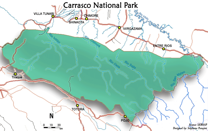
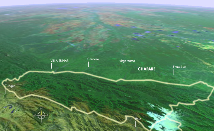
Carrascon kansallispuisto sijaitsee Cochabamban
departementin puolella. Pääsy puistoon on samaa Santa Cruz-Cochabamba tietä
pitkin kuin Amboroonkin. Puiston nähtävyyksiin kuuluvat Repechón luolat (Cavernas
del Repechón), joissa on lepakoita ja
rasvakehrääjiä (guácharos), San
Rafael - ja San Mateo -joet sekä Incachaca-rauniot. Sehuencas mainitaan hyvänä
leiripaikkana. Puistoon pääsemiseen pitää olla lupa. Lupia voi ostaa Cochabambasta
tai puistosta.
Amboro National Park sits side by side with National
Park of Carrasco. The entrance to Carrasco is along the same Santa
Cruz-Cochabamba road as to Amboro. The attractions of the Carrasco National
Park include the canes of Repechón (Cavernas del Repechón), caves with bats and oilbirds (guácharos), rivers San Rafael and
San Mateo and the ruins of Incachaca. Sehuencas is mentioned to be a good
camping place. Permission is needed to get into the park. Permissions can be
bought from Cochabamba or from the park itself.
* harvaan asuttu puoliaron peittämä
kuuma tasankoalue.
A parsely populated hot semi-arid
lowland area.
**metsäalue Andien itärinteillä,
vaihettumisvyöhyke Andien ylängön ja itäisten metsien välillä. Kosteaa, sateista ja lämmintä
aluetta.
A stretch of forest along the
eastern slope of the Andes. It’s a transitional zone between the Andean
highlands and the eastern forests. Rainy, humid, and warm.
Lähteet/Sources:
Wikipedia
http://www.buenavistabolivia.com/
Tiedotti teille
Sonja tiedonhankintaryhmästä
Nyt kun luin tämän uudestaan 1,5 vuoden jälkeen, niin tää näyttäytyy ihan toisessa valossa nyt. Tuonne sitä ollaan menossa ja paikka vaikuttaa aivan mahtavalta!
VastaaPoista